
Santa Cruz County has the highest number of natural hazards per square mile than any other county in the state of California. Take a look around, and you’ll see why.
Stand on West Cliff Drive near the lighthouse and watch as waves crash against the bluff, forming a fountain of spray high into the air. Hike along Aptos Creek and up to the epicenter of the Loma Prieta earthquake, where steep canyons slice into the earth hundreds of feet down, making you watch every step. Witness the wonder of a charred landscape from wildfire coming back to life with wildflowers and birds.
All this amazing beauty is created by natural hazards. Water, fire, and the constant shift of the earth’s surface. Santa Cruz is on the very edge of a seam that stitches two continents together. And lucky (and sometimes unlucky) for us, that’s where all the action is.
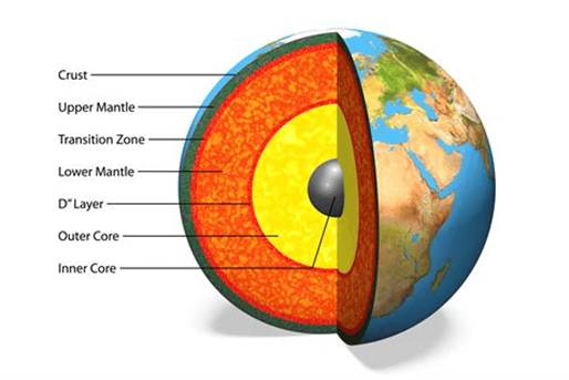
The earth’s surface is in constant motion. Why? Because the part of the earth (mantle) below the surface is almost a fluid, heated by the interior core of the earth’s center. The surface of the earth (crust) floats atop this almost-fluid mantle and its motion is driven by the heat. The earth’s crust is very thin, comparable to the rest of the planet. See the graphic below, showing a cutaway of Earth.
Think about a pot of soup warming up on the stove. The surface is cold, and somewhat rigid, while beneath it is warm and fluid. As the heat rises, it creates motion in the crust, which begins to break up and drift around. You might have heard of Pangea, the ancient “super continent” that was pretty much one big hunk of crust surrounded by ocean. As the years went on (we’re talking millions), the crust, heated by the mantle, began to split apart and drift, creating more oceans and spreading apart the continents (plates) into what they are today.
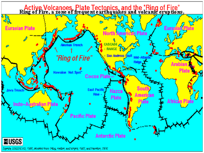
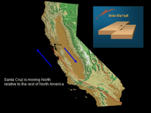
At this rate (again, millions of years from now) part of California will be an island near Alaska! How do we know? Because California is divided by a plate boundary, that seam stitching two continental plates together. The continental plates shift and move along their boundaries. Our neighbor, the San Andreas Fault, forms that seam between the North American Plate and the Pacific Plate. What side are we on? The Pacific. Which is on the move.
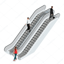
The Pacific Plate is moving northward, slow and steady, as ocean floor, carried along for the ride, gets eaten up and recycled in a subduction zone far north. Think of a subduction zone like an escalator. Next time you’re at the mall get on one going down. You’re standing on ocean floor, and since ocean floor rock is more dense than continental rock, when the two collide, the ocean floor sinks UNDER the continent. It drops down like an escalator, where it eventually melts in the hot interior of the earth and rises up again through volcanoes.
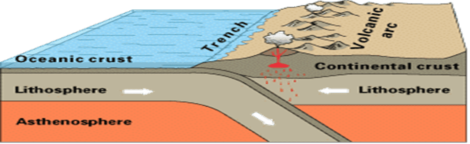
About twenty million years ago Nevada was ocean-front property, when another plate, the Juan de Fuca, was sinking below the North American Plate. Ocean floor was the “escalator” riding downward under Nevada and melting in the hot interior, then rising up like the lava in a lava lamp (remember those?) and punching through the earth’s crust into hundreds of volcanoes that formed the Sierra Nevada mountain range. Water did its job to erode these mountains and volcanoes, creating what is now the Central Valley.
Eventually, subduction slowed, and the Juan de Fuca Plate was pushed out of the way to the north by the Pacific Plate, which was moving northwestward. It collided with the North American Plate at an angle and tore away a chunk of it, taking it along for the ride. This chunk became the part of California to the west of the San Andreas Fault. All that drama of the collision and subsequent move north is what makes California what it is today. If you live in Bonny Doon, the land you walk on used to be where the Mojave Desert is today, and the bedrock is actually a part of the southern Sierra Nevada.
Okay, you’re talking about escalators and plate boundaries. How does that relate to Santa Cruz and all its natural hazards?
Remember that seam, the plate boundary where all the action happens? That action translates to earthquakes and mountain building. This in turn creates the dramatic landscapes, that are exposed to constant erosion from rainfall.
UP NEXT: What anyone who’s driven Highway 17 has seen at least once:
Landslides! (To be continued)

Chris has over 23 years of experience in Natural Hazard Disclosure reporting. GeoDisclosure has been a great success because Chris believes that having a responsive and reliable service is the number one.